Google Maps (internet browser, PC)
This is the preferred and most versatile method for viewing Street View Imagery.
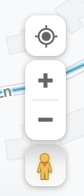
Browse to Google Maps (www.google.com/maps) on a PC or Laptop in the internet browser.Click the Pegman icon in the bottom right corner of the application window. This will change all of the areas that have Google Street View Imagery blue. Blue lines represent roads and outdoor paths and blue dots for interior virtual tours.


Click on a blue line or blue dot to view the closest Street View Image.

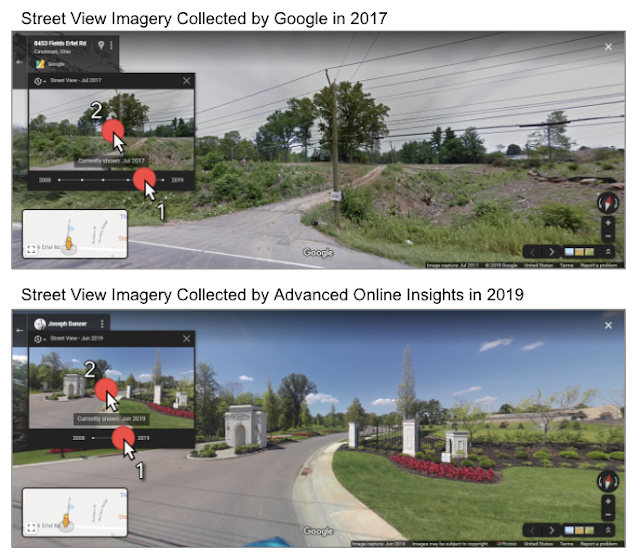
How to view Historical Street View imagery (when available)
- Click on the timeline icon in the top left corner of the screen to activate the timeline window.
- Click the dot on the timeline to select the imagery collected that year.
- Then click above the timeline on the image to view the Street View Image.
Alternate Method to view Street View imagery:
Click & Drag: Click & hold, the “Browse Street View Images” icon in the bottom right corner of the application window. Drag the Pegman icon onto the area of the map you wish to view Street View.

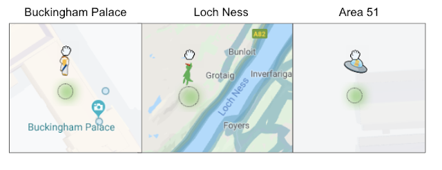
Bonus: Just for fun!
There are various locations on Google Maps where Pegman will transform into different characters. How many can you find?
Google Earth Pro (free application, PC)
Versatile Mapping Platform with customizable options.
How to view Street View imagery:
Click & hold the Pegman icon in the top right corner of the application window. Drag Pegman onto the area of the map you wish to view, and drop him to enter Street View.
To return to the map view, click the “Exit Street View” button in the top right corner of the application.

Google Earth (internet browser, PC)
Access Street View in a 3D mapping environment.
How to view Street View imagery:
Browse to Google Earth (earth.google.com/web) on a PC or Laptop in the internet browser.
Click the “Browse Street View Images” icon in the bottom right corner of the application window. This will change all of the areas that have Google Street View Imagery blue. Blue lines represent roads and outdoor paths and blue dots for interior virtual tours.

Google Earth (internet browser, PC)
Access Street View in a 3D mapping environment.
How to view Street View imagery: (continued)
Click on a blue line or blue dot to view the closest Street View Image.

Click on Pegman in the bottom right corner of the application to exit Street View

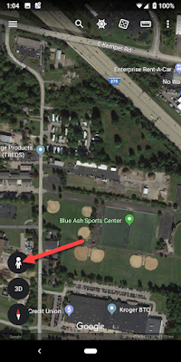
Google Earth (mobile app)
Access Street View in a 3D mapping environment on your mobile device.
How to view Street View imagery:
Open the Google Earth app on your mobile device and zoom into the area of interest on the map.
Tap the Pegman icon in the bottom left corner of the screen to activate the Street View visibility mode on the application.
Tap a location highlighted in blue to enter Street View.
Tap the Pegman icon Tap a location highlighted in blue.

Tap the arrows or swipe up and swipe down on blue road lines to navigate Street View.
Tap the back arrow in the top left corner of the app to exit Street View.

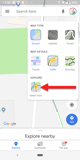
Google Maps (mobile app)
Best app to view virtual tours on mobile devices.
Open the Google Maps app on your mobile device and navigate to the area of interest on the map.
Tap the Layers icon in the top right hand corner of the application
Tap the Street View icon in the application window. This will change all of the areas that have Google Street View Imagery into blue lines.
Note: Currently only native Google Street View is showing up as blue lines on the Google Maps mobile app. Use the Google Earth mobile app to show all available Street View Imagery.


Tap a location highlighted in blue to enter Street View.
Tap the arrows or swipe up and swipe down on blue road lines to navigate Street View.
Tap the back arrow in the top left corner of the app to exit Street View.
Tap the arrows or swipe up and swipe down on blue road lines to navigate Street View.
Tap the back arrow in the top left corner of the app to exit Street View.

Note: Currently only native Google Street View is showing up as blue lines on the Google Maps mobile app. Use the Google Earth mobile app to show all available Street View Imagery.
Google Street View (mobile app)
Mobile App with a Virtual Reality / Google Cardboard Viewer
How to view Street View imagery:
Open the Google Street View app on your mobile device and navigate to the area of interest on the map.
Tap the Street View image at the bottom of the screen to activate Street View.
Tap and drag your screen to see your surroundings.
Tap the arrows or swipe up and swipe down on blue road lines to navigate Street View.
To enter the Virtual Reality viewer, click the Google Cardboard icon in the top right corner of the screen.


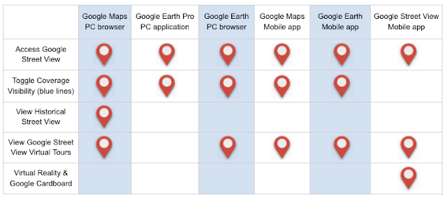
Street View Application Comparison
Each application that can view Google Street View has slight variations of how to activate Street View along with the features that they provide. Below is a chart that shows which features are available in each application.